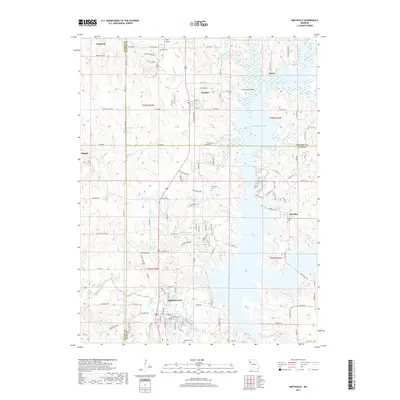
2017 Map of Smithville
USGS Topo · Published 2017About this map
Smithville and its surrounding rural landscapes are defined by the intricate shoreline of the Little Platte River system as it appeared in the late 2010s. The map illustrates a region where family history is deeply rooted, marked by several small burial grounds including Reed Cem, Davenport Cem, and Paradise Cem. The settlement of Paradise sits near the eastern finger of the water, while Trimble is positioned to the north, adjacent to the sprawling Trimble Wildlife Lake. Significant water bodies like Kings Lake, Miller Lake, and Lake Remote punctuate the terrain, reflecting the modern hydrological management of the Platte and Clay County borders. Local infrastructure is represented by features such as Starr Airport and the Linn Branch Bridge, alongside a dense network of country roads like SW Kings Rd CO RD 304 and Buena Vista Rd that connect these longstanding Missouri communities.
Find a feature on this map
80 named features on this map. Tap any name to fly to it.
Don’t see what you’re looking for? This feature index may not catch every label — zoom into the map to look around manually.
Map Details
Editions of this 2017 Smithville Map
This is the sole edition of this map. No revisions or reprints were ever made.
Other maps of this area

1890 · Kansas City
USGS Topo · 1:125,000

1894 · Kansas City
USGS Topo · 1:125,000

1894 · Independence
USGS Topo · 1:125,000

1914 · Smithville
USGS Topo · 1:62,500

1925 · Gower
USGS Topo · 1:62,500

1925 · Plattsburg
USGS Topo · 1:62,500

1936 · Kearney
USGS Topo · 1:48,000

1942 · Kearney
USGS Topo · 1:62,500

1945 · Kearney
USGS Topo · 1:62,500
1948 · Nashua
USGS Topo · 1:24,000