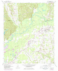
1966 Map of Smithville
USGS Topo · Published 1985About this map
The Tombigbee River meanders through this landscape, defining the transition between the rolling hills of the Mountain area and the low-lying wetlands. The town of Smithville serves as a primary hub, while the northern edge of Amory appears in the southwest corner. Transportation and commerce are centered around the Mississippian railroad line and a network of gravel roads connecting rural outposts like Jericho and Carolina.
Find a feature on this map
40 named features on this map. Tap any name to fly to it.
Don’t see what you’re looking for? This feature index may not catch every label — zoom into the map to look around manually.
Map Details
Editions of this 1966 Smithville Map
2 editions found
Other maps of this area

1953 · West Point
USGS Topo · 1:250,000

1956 · Tupelo
USGS Topo · 1:250,000

1958 · Tupelo
USGS Topo · 1:250,000

1958 · West Point
USGS Topo · 1:250,000

1963 · West Point
USGS Topo · 1:250,000

1966 · Smithville
USGS Topo · 1:24,000

1966 · Beans Ferry
USGS Topo · 1:24,000

1966 · Amory
USGS Topo · 1:24,000

1966 · Turon
USGS Topo · 1:24,000

1966 · Wren
USGS Topo · 1:24,000