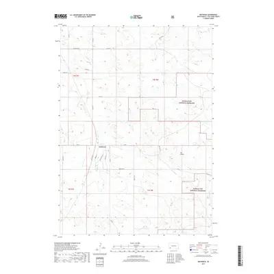
2017 Map of Smithwick
USGS Topo · Published 2017About this map
The small settlement of Smithwick serves as a central point in this South Dakota landscape, where the prairie meets the drainage networks of the Cheyenne River basin. Situated in Fall River County, the area is defined by its wide-open spaces and the intricate system of intermittent streams including Sand Cr and Plumb Cr. Large portions of the eastern and southern territory are protected under the Buffalo Gap National Grassland, reflecting a land use pattern focused on conservation and livestock grazing. The local road network, with names like Dead Tree Rd and Sharptail Rd, underscores the rural character of the region. Local history is anchored near the townsite, marked by Cemetary Rd, while the terrain to the east is carved by Hay Canyon and the winding course of Kennedy Cr, illustrating the rugged topography of the Great Plains.
Find a feature on this map
29 named features on this map. Tap any name to fly to it.
Don’t see what you’re looking for? This feature index may not catch every label — zoom into the map to look around manually.
Map Details
Editions of this 2017 Smithwick Map
This is the sole edition of this map. No revisions or reprints were ever made.
Other maps of this area

1896 · Oelrichs
USGS Topo · 1:125,000

1900 · Oelrichs
USGS Topo · 1:125,000

1950 · Buffalo Gap
USGS Topo · 1:24,000

1950 · Hot Springs SE
USGS Topo · 1:24,000

1951 · Smithwick NE
USGS Topo · 1:24,000

1951 · Smithwick NW
USGS Topo · 1:24,000

1955 · Hot Springs
USGS Topo · 1:250,000
1982 · Smithwick
USGS Topo · 1:25,000
1982 · Hay Canyon Butte
USGS Topo · 1:25,000
1982 · Lone Well Creek East
USGS Topo · 1:24,000