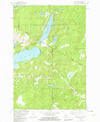
1981 Map of Smoky Lake
USGS Topo · Published 1981About this map
Smoky Lake and Big Sand Lake dominate this borderland landscape, where the northern woods of Michigan meet the lake country of Wisconsin. This 1981 survey depicts a region defined by extensive forest management and recreation, split between the Ottawa National Forest to the north and the Nicolet National Forest to the south. The presence of the Phelps Municipal Landing Strip and a Golf Course near the shores of Smoky Lake suggests a developed seasonal character even in this heavily forested area. The map traces the intricate water network of the Phelps and Alvin townships, including the headwaters of Elvoy Creek at Elvoy Springs and the secluded Jewel Lake. The state boundary itself zig-zags through the terrain, cutting across timberlands and several smaller water bodies like Little Smoky Lake and Horseshoe Lake.
Find a feature on this map
42 named features on this map. Tap any name to fly to it.
Don’t see what you’re looking for? This feature index may not catch every label — zoom into the map to look around manually.
Map Details
Editions of this 1981 Smoky Lake Map
3 editions found
Other maps of this area

1928 · Three Lakes
USGS Topo · 1:48,000

1938 · Phelps
USGS Topo · 1:48,000

1938 · Alvin
USGS Topo · 1:48,000

1938 · Three Lakes
USGS Topo · 1:48,000

1945 · Three Lakes
USGS Topo · 1:48,000

1946 · Alvin
USGS Topo · 1:48,000

1950 · Phelps
USGS Topo · 1:48,000

1954 · Iron Mountain
USGS Topo · 1:250,000

1956 · Beechwood
USGS Topo · 1:62,500

1956 · Phelps
USGS Topo · 1:62,500