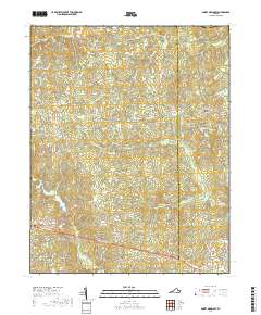
2019 Map of Smoky Ordinary
USGS Topo · Published 2019About this map
Smoky Ordinary and the surrounding rural communities of Adsit and Callaville anchor this part of Southside Virginia near the border of Brunswick and Greensville counties. The landscape is defined by the drainage systems of Sturgeon Cr and Three Cr, with numerous smaller tributaries like Cooks Br and Indian Cr carving through the terrain. The presence of several family and community burial grounds, such as Raney Cem and Zion Cem, alongside the Emmanuel Cem, provides valuable points of reference for genealogists tracking local lineages in this historically agricultural region.
Find a feature on this map
54 named features on this map. Tap any name to fly to it.
Don’t see what you’re looking for? This feature index may not catch every label — zoom into the map to look around manually.
Map Details
Editions of this 2019 Smoky Ordinary Map
This is the sole edition of this map. No revisions or reprints were ever made.
Other maps of this area

1918 · Lawrenceville
USGS Topo · 1:62,500

1919 · Mc Kenney
USGS Topo · 1:48,000

1919 · White Plains
USGS Topo · 1:48,000

1919 · Emporia
USGS Topo · 1:62,500

1920 · Lawrenceville
USGS Topo · 1:48,000

1920 · White Plains
USGS Topo · 1:62,500

1921 · Mc Kenney
USGS Topo · 1:62,500

1921 · Lawrenceville
USGS Topo · 1:62,500

1942 · Lawrenceville
USGS Topo · 1:62,500

1942 · Emporia
USGS Topo · 1:62,500