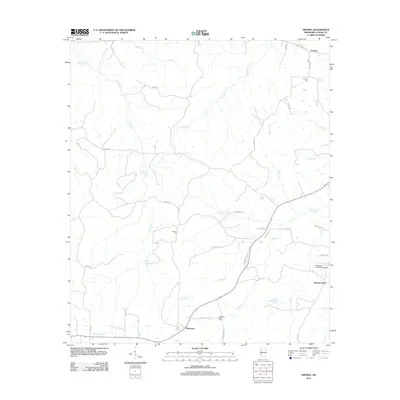
2012 Map of Smyrna
USGS Topo · Published 2012About this map
Smyrna and Bowerton anchor this rural landscape in Copiah County, where a complex network of creeks and small drainages defines the local geography. The area's history is reflected in its scattered burial grounds, including Smyrna Cem in the north and Antioch Cem further south. To the southeast, Browns Wells and the nearby Kaywood Plantation Airport indicate more modern development amidst the agricultural terrain. Long-established travel routes like Old Port Gibson Rd and the Old Highway 20 Loop cut through the hills, providing a framework for the rural homesteads and farms. Water sources such as Jackson Cr, Halls Cr, and Bishop Cr wind through the quadrangle, illustrating the natural irrigation that has long supported the region's land use patterns.
Find a feature on this map
45 named features on this map. Tap any name to fly to it.
Don’t see what you’re looking for? This feature index may not catch every label — zoom into the map to look around manually.
Map Details
Editions of this 2012 Smyrna Map
This is the sole edition of this map. No revisions or reprints were ever made.
Other maps of this area

1953 · Natchez
USGS Topo · 1:250,000

1956 · Natchez
USGS Topo · 1:250,000

1959 · Natchez
USGS Topo · 1:250,000

1963 · Dentville NW
USGS Topo · 1:24,000

1963 · Dentville
USGS Topo · 1:24,000

1963 · Smyrna
USGS Topo · 1:24,000
1963 · Gallman
USGS Topo · 1:24,000

1963 · Hazlehurst
USGS Topo · 1:24,000

1963 · Barlow
USGS Topo · 1:24,000

1972 · Midway
USGS Topo · 1:24,000