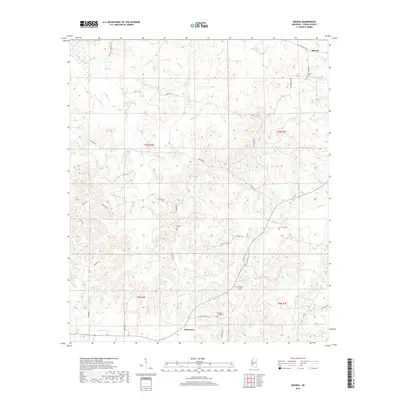
2018 Map of Smyrna
USGS Topo · Published 2018About this map
Smyrna and Bowerton anchor this survey of western Copiah County, where the landscape is defined by the intricate drainages of Thompson Cr and Jackson Cr. The settlement pattern follows established ridge routes like Old Port Gibson Rd and Barlow Rd, reflecting the historical overland connection between the interior and the Mississippi River. Genealogists will find several community burial sites, including Antioch Cem and Millsaps Cem, which mark the centers of local social and religious life. The network of smaller roads such as Halls Hill Church Ln and Pleasant Valley Rd highlights the decentralized rural character of the area, where clusters of homes and small farms have persisted along the creek bottoms and timbered uplands into the twenty-first century.
Find a feature on this map
40 named features on this map. Tap any name to fly to it.
Don’t see what you’re looking for? This feature index may not catch every label — zoom into the map to look around manually.
Map Details
Editions of this 2018 Smyrna Map
This is the sole edition of this map. No revisions or reprints were ever made.
Other maps of this area

1953 · Natchez
USGS Topo · 1:250,000

1956 · Natchez
USGS Topo · 1:250,000

1959 · Natchez
USGS Topo · 1:250,000

1963 · Dentville NW
USGS Topo · 1:24,000

1963 · Dentville
USGS Topo · 1:24,000

1963 · Smyrna
USGS Topo · 1:24,000
1963 · Gallman
USGS Topo · 1:24,000

1963 · Hazlehurst
USGS Topo · 1:24,000

1963 · Barlow
USGS Topo · 1:24,000

1972 · Midway
USGS Topo · 1:24,000