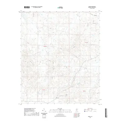
2020 Map of Smyrna
USGS Topo · Published 2020About this map
Smyrna and Bowerton anchor this Copiah County landscape, where the terrain is defined by a dense network of creek drainages including Halls Cr and Thompson Cr. The road network provides evidence of historical travel patterns and family settlements, highlighted by the Old Port Gibson Rd and Wilderness Rd. For those tracing local heritage, several small burial grounds are dispersed across the area, such as Smyrna Cem in the northeast and Milsaps Cem to the south. The southern portion of the map is particularly centered around the rural community near Bowerton, where Pleasant Valley Rd leads toward Pleasant Valley Cem. The map's layout reflects a transition from larger thoroughfares to winding lanes like Walnut Hills Ln, following the contours of the Mississippi countryside.
Find a feature on this map
42 named features on this map. Tap any name to fly to it.
Don’t see what you’re looking for? This feature index may not catch every label — zoom into the map to look around manually.
Map Details
Editions of this 2020 Smyrna Map
This is the sole edition of this map. No revisions or reprints were ever made.
Other maps of this area

1953 · Natchez
USGS Topo · 1:250,000

1956 · Natchez
USGS Topo · 1:250,000

1959 · Natchez
USGS Topo · 1:250,000

1963 · Dentville NW
USGS Topo · 1:24,000

1963 · Dentville
USGS Topo · 1:24,000

1963 · Smyrna
USGS Topo · 1:24,000
1963 · Gallman
USGS Topo · 1:24,000

1963 · Hazlehurst
USGS Topo · 1:24,000

1963 · Barlow
USGS Topo · 1:24,000

1972 · Midway
USGS Topo · 1:24,000