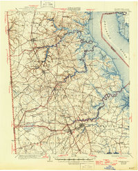
1931 Map of Smyrna
USGS Topo · Published 1946About this map
Smyrna and the surrounding agricultural districts of Kent and New Castle Counties are shown here during a period of significant transition in Delaware's transportation infrastructure. The Pennsylvania Railroad runs through the heart of the region, supporting agricultural hubs like Townsend and Middletown, while the newly established Dupont Highway signals the rising dominance of motor travel. Along the tidal reaches of Appoquinimink Creek and Blackbird Creek, a series of landings—including Blackbird Landing and Flemings Landing—reveal the persistent importance of waterborne trade in the low-lying coastal marshes.
Find a feature on this map
111 named features on this map. Tap any name to fly to it.
Don’t see what you’re looking for? This feature index may not catch every label — zoom into the map to look around manually.
Map Details
Editions of this 1931 Smyrna Map
5 editions found

Other maps of this area

1890 · Salem
USGS Topo · 1:62,500

1890 · Bay Side
USGS Topo · 1:62,500

1894 · Bay Side
USGS Topo · 1:62,500

1898 · Salem
USGS Topo · 1:62,500

1898 · Elkton
USGS Topo · 1:62,500

1899 · Vineland
USGS Topo · 1:125,000

1899 · Dover
USGS Topo · 1:125,000

1900 · Elkton
USGS Topo · 1:62,500

1900 · Cecilton
USGS Topo · 1:62,500

1901 · Camden
USGS Topo · 1:125,000