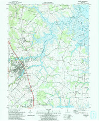
1993 Map of Smyrna
USGS Topo · Published 1993About this map
The Smyrna community serves as the central hub of this northern Kent County landscape, where the Smyrna River and Duck Creek carve through the low-lying coastal plain toward the Delaware Bay. The early 1990s layout reveals a transition from traditional agricultural clusters like Deakyneville and Chambersville to more modern residential developments such as Green Meadows and McLane Gardens. Significant land use is dedicated to the Delaware Correction Center to the north and the expansive Bombay Hook National Wildlife Refuge along the eastern wetlands.
Find a feature on this map
97 named features on this map. Tap any name to fly to it.
Don’t see what you’re looking for? This feature index may not catch every label — zoom into the map to look around manually.
Map Details
Editions of this 1993 Smyrna Map
This is the sole edition of this map. No revisions or reprints were ever made.
Other maps of this area

1890 · Bay Side
USGS Topo · 1:62,500

1894 · Bay Side
USGS Topo · 1:62,500

1899 · Vineland
USGS Topo · 1:125,000

1899 · Dover
USGS Topo · 1:125,000

1906 · Dover
USGS Topo · 1:125,000

1919 · Vineland
USGS Topo · 1:125,000

1920 · Dover
USGS Topo · 1:125,000

1926 · Wyoming
USGS Topo · 1:48,000

1930 · Wyoming
USGS Topo · 1:62,500

1931 · Wyoming
USGS Topo · 1:62,500
Featured Places
- Smyrna, DE
- Colmar Manor, DE
- Village of Garrison Lake, DE
- Woodland Court Mobile Home Park, DE
- Hedgerow Hollow Mobile Home Park, DE