
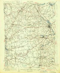
1931 Map of Wyoming
USGS Topo · Published 1931About this map
The state capital of Dover serves as the eastern anchor for this 1920s-era landscape, where the Pennsylvania Railroad corridor facilitates the growth of agricultural hubs like Wyoming and Felton. This map reveals a densely settled interior of central Delaware and adjacent Maryland, defined by small rural schools and family-named landmarks such as Dinaus Corner and Lords Corner. The presence of the County Poor Farm and numerous mills, including Voshell Mill and Lexington Mill, illustrates the social and industrial infrastructure of Kent County before the mid-century expansion of modern highways. Water power remains central to the economy, with Andrews Lake and Silver Lake punctuating a network of branches and runs that flow toward the St Jones River. Local genealogy and land patterns are further detailed through the locations of rural congregations like Bethel and Asbury Ch.
Find a feature on this map
126 named features on this map. Tap any name to fly to it.
Don’t see what you’re looking for? This feature index may not catch every label — zoom into the map to look around manually.
Map Details
Editions of this 1931 Wyoming Map
2 editions found
Other maps of this area

1890 · Bay Side
USGS Topo · 1:62,500

1894 · Bay Side
USGS Topo · 1:62,500

1899 · Vineland
USGS Topo · 1:125,000

1899 · Dover
USGS Topo · 1:125,000

1900 · Cecilton
USGS Topo · 1:62,500

1905 · Denton
USGS Topo · 1:62,500

1905 · Barclay
USGS Topo · 1:62,500

1906 · Dover
USGS Topo · 1:125,000

1918 · Cedar Creek
USGS Topo · 1:62,500

1918 · Harrington
USGS Topo · 1:62,500