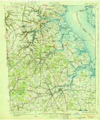
1931 Map of Smyrna
USGS Topo · Published 1931About this map
The Pennsylvania Railroad corridor and the Dupont Highway anchor this 1931 survey of the Delaware landscape, where the agricultural interior meets the tidal reaches of the Delaware River. The map documents a transition from water-based commerce to modern land transport, featuring numerous historic riverside points such as Thomas Landing, Shorts Landing, and Eagles Nest Landing along the winding banks of Appoquinimink Creek and Duck Creek.
Find a feature on this map
109 named features on this map. Tap any name to fly to it.
Don’t see what you’re looking for? This feature index may not catch every label — zoom into the map to look around manually.
Map Details
Editions of this 1931 Smyrna Map
5 editions found

Other maps of this area

1890 · Salem
USGS Topo · 1:62,500

1890 · Bay Side
USGS Topo · 1:62,500

1894 · Bay Side
USGS Topo · 1:62,500

1898 · Salem
USGS Topo · 1:62,500

1898 · Elkton
USGS Topo · 1:62,500

1899 · Vineland
USGS Topo · 1:125,000

1899 · Dover
USGS Topo · 1:125,000

1900 · Elkton
USGS Topo · 1:62,500

1900 · Cecilton
USGS Topo · 1:62,500

1901 · Camden
USGS Topo · 1:125,000