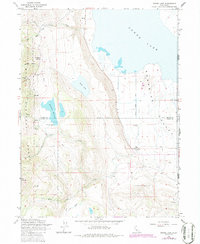
1962 Map of Snake Lake
USGS Topo · Published 1986About this map
Surprise Valley and the high elevations of the South Warner Wilderness dominate this corner of the California-Nevada borderlands. The landscape transitions sharply from the rugged terrain of the Modoc National Forest, marked by peaks like Hat Mountain, down to the alkaline flats of Lower Lake. Water management is central to the area's geography, evidenced by the Sworinger Reservoir and its spillway, alongside natural features like Snake Lake and numerous canyon-side springs.
Find a feature on this map
29 named features on this map. Tap any name to fly to it.
Don’t see what you’re looking for? This feature index may not catch every label — zoom into the map to look around manually.
Map Details
Editions of this 1962 Snake Lake Map
4 editions found
Other maps of this area

1886 · Alturas
USGS Topo · 1:250,000

1889 · Long Valley
USGS Topo · 1:250,000

1892 · Alturas
USGS Topo · 1:250,000

1954 · Vya
USGS Topo · 1:250,000

1954 · Alturas
USGS Topo · 1:250,000

1958 · Alturas
USGS Topo · 1:250,000

1958 · Vya
USGS Topo · 1:250,000

1962 · Alturas
USGS Topo · 1:250,000

1962 · Vya
USGS Topo · 1:250,000

1962 · Snake Lake
USGS Topo · 1:24,000