
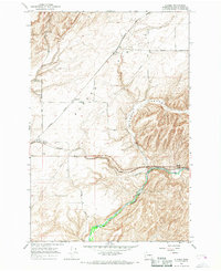
1966 Map of Snake River
USGS Topo · Published 1967About this map
Lake Sacagawea dominates the canyon landscape in this mid-1960s survey, following the flooding of the Snake River valley behind regional dams. This transition from a flowing river to a slackwater reservoir is captured during a period when grain transport remained a primary local industry, evidenced by the clusters of Grain Elevators and storage bins positioned along the water's edge.
Find a feature on this map
32 named features on this map. Tap any name to fly to it.
Don’t see what you’re looking for? This feature index may not catch every label — zoom into the map to look around manually.
Map Details
Editions of this 1966 Snake River Map
This is the sole edition of this map. No revisions or reprints were ever made.
Other maps of this area

1915 · Wallulah
USGS Topo · 1:96,000

1916 · Connell
USGS Topo · 1:125,000

1918 · Connell
USGS Topo · 1:125,000

1918 · Wallula
USGS Topo · 1:125,000

1953 · Walla Walla
USGS Topo · 1:250,000

1958 · Walla Walla
USGS Topo · 1:250,000

1964 · Levey SE
USGS Topo · 1:24,000

1964 · Levey NE
USGS Topo · 1:24,000

1966 · Page
USGS Topo · 1:24,000
1966 · Eureka
USGS Topo · 1:24,000