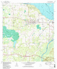
1994 Map of Sneads
USGS Topo · Published 1998About this map
Sneads and its surrounding riverine landscape are defined by the convergence of the Chattahoochee River and the Apalahicola River at the massive Lake Seminole reservoir. This area in Jackson County reflects a complex mix of public land management, state facilities, and traditional rural settlements during the late twentieth century. Large-scale institutional footprints like the Apalachee Correctional Institution and Three Rivers State Park occupy the eastern shoreline, while the town of Sneads serves as a central hub near the intersection of major rail and road corridors. Further west, the map details smaller communities like Inwood and Grand Ridge, where the terrain shifts toward the wetlands of Ochesee Pond. Genealogists will find numerous family and community sites recorded, including Pope Cem, Sardis Cem, and Sinai Ch, alongside industrial markers like the Jackson County Port and a powerplant near the river bend.
Find a feature on this map
48 named features on this map. Tap any name to fly to it.
Don’t see what you’re looking for? This feature index may not catch every label — zoom into the map to look around manually.
Map Details
Editions of this 1994 Sneads Map
This is the sole edition of this map. No revisions or reprints were ever made.
Other maps of this area

1952 · Cypress
USGS Topo · 1:24,000

1952 · Dellwood
USGS Topo · 1:24,000

1952 · Altha East
USGS Topo · 1:24,000

1954 · Sneads
USGS Topo · 1:24,000

1954 · Tallahassee
USGS Topo · 1:250,000

1955 · Fairchild
USGS Topo · 1:24,000

1955 · Reynoldsville
USGS Topo · 1:24,000

1955 · Rock Bluff
USGS Topo · 1:24,000

1955 · Sycamore
USGS Topo · 1:24,000

1955 · Chattahoochee
USGS Topo · 1:24,000