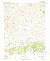
1962 Map of Snelling
USGS Topo · Published 1963About this map
The Merced River corridor dominates this 1962 landscape, revealing a riverbed fundamentally altered by industrial history. Extensive Dredge Tailings flank the water, marking the legacy of gold dredging operations that reshaped the valley floor near the community of Snelling. This settlement serves as a local hub, featuring the Snelling-Merced Falls Sch and Henderson Park. Evidence of earlier transportation and water management is clear, with an Old Railroad Grade running parallel to the river and a complex network of irrigation infrastructure including the North Side Canal, Main Canal, and a Diversion Dam. North of the river, the terrain transitions into a series of drainages like Dry Creek and Hayward Creek, punctuated by landmarks such as Negro Hill. The map also documents the convergence of several county boundaries, where the Merced, Stanislaus, and Mariposa county lines meet in the rolling foothills.
Find a feature on this map
31 named features on this map. Tap any name to fly to it.
Don’t see what you’re looking for? This feature index may not catch every label — zoom into the map to look around manually.
Map Details
Editions of this 1962 Snelling Map
3 editions found
Other maps of this area

1893 · Sonora
USGS Topo · 1:125,000

1896 · Sonora
USGS Topo · 1:125,000

1897 · Sonora
USGS Topo · 1:125,000

1898 · Sonora
USGS Topo · 1:125,000

1913 · Dickenson
USGS Topo · 1:31,680

1915 · La Grange
USGS Topo · 1:24,000

1916 · Three Tree Flat
USGS Topo · 1:31,680

1916 · Hopeton
USGS Topo · 1:31,680

1916 · Cooperstown
USGS Topo · 1:31,680

1916 · Merced Falls
USGS Topo · 1:24,000