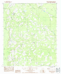
1988 Map of Sniders Crossroads
USGS Topo · Published 1988About this map
Sniders Crossroads and Bells Crossroads anchor this rural Colleton County landscape during the late 1980s, where the winding course of the Little Salkehatchie River defines the western edge of the quadrangle. The terrain is characterized by a series of elliptical wetlands and drainages typical of the South Carolina Lowcountry, including Deep Bottom Bay, Fosters Bay, and Horse Bay. These natural features, along with waterways like Deep Bottom Creek and Indian Creek, dictated the historical placement of roads and homesteads.
Find a feature on this map
21 named features on this map. Tap any name to fly to it.
Don’t see what you’re looking for? This feature index may not catch every label — zoom into the map to look around manually.
Map Details
Editions of this 1988 Sniders Crossroads Map
This is the sole edition of this map. No revisions or reprints were ever made.
Other maps of this area

1918 · Walterboro
USGS Topo · 1:62,500

1919 · Cummings
USGS Topo · 1:62,500

1919 · Lodge
USGS Topo · 1:62,500

1920 · Lodge
USGS Topo · 1:48,000

1920 · St. George
USGS Topo · 1:48,000

1921 · Lodge
USGS Topo · 1:62,500

1921 · St. George
USGS Topo · 1:62,500

1943 · Lodge
USGS Topo · 1:62,500

1943 · Orangeburg
USGS Topo · 1:125,000

1943 · Cummings
USGS Topo · 1:62,500