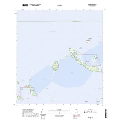
2024 Map of Snipe Keys
USGS Topo · Published 2024About this map
The Great White Heron National Wildlife Refuge encompasses a vast marine and island landscape within the Florida Keys, characterized by intricate mangrove systems and shallow tidal basins. This modern survey illustrates the complex geography of the Snipe Keys and Mud Keys, highlighting the narrow passages that define navigation in these waters, such as the Outer Narrows and Mud Key Channel. To the south and west, the map details numerous named features like Cayo Agua and the Lower Harbor Keys, which sit near the broader Jewfish Basin. The placement of landmarks like Old Dan Mangrove and Fish Hawk Key reflects a coastal environment shaped by historical naming conventions and ecological preservation, situated just off the Intracoastal Waterway.
Find a feature on this map
35 named features on this map. Tap any name to fly to it.
Don’t see what you’re looking for? This feature index may not catch every label — zoom into the map to look around manually.
Map Details
Editions of this 2024 Snipe Keys Map
This is the sole edition of this map. No revisions or reprints were ever made.
Other maps of this area

1921 · Sugar Loaf Key
USGS Topo · 1:62,500

1921 · Key West
USGS Topo · 1:62,500

1943 · Bay Keys
USGS Topo · 1:24,000

1943 · Saddlebunch Keys
USGS Topo · 1:24,000

1943 · Boca Chica
USGS Topo · 1:24,000

1943 · Key West
USGS Topo · 1:24,000

1943 · Snipe Keys
USGS Topo · 1:24,000

1943 · Sugarloaf Key
USGS Topo · 1:24,000

1962 · Key West
USGS Topo · 1:24,000

1968 · Saddlebunch Keys
USGS Topo · 1:24,000