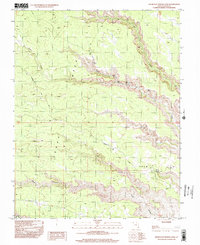
1996 Map of Snow Flat Spring Cave
USGS Topo · Published 2002About this map
Cedar Mesa dominates this 1996 provisional survey, a high-desert plateau marked by deep drainages and geological landmarks in San Juan County. The sheet focuses on the complex canyon systems carved by Owl Creek and Fish Creek, which converge amidst several notable natural spans including Nevills Arch and another Natural Arch. These deep incisions in the mesa provided natural shelters and water sources, such as the named Snow Flat Spring Cave located along the eastern edge of Snow Flat.
Find a feature on this map
16 named features on this map. Tap any name to fly to it.
Don’t see what you’re looking for? This feature index may not catch every label — zoom into the map to look around manually.
Map Details
Editions of this 1996 Snow Flat Spring Cave Map
This is the sole edition of this map. No revisions or reprints were ever made.
Other maps of this area

1886 · Abajo
USGS Topo · 1:250,000

1892 · Abajo
USGS Topo · 1:250,000

1893 · Abajo
USGS Topo · 1:250,000

1935 · Elk Ridge
USGS Topo · 1:96,000

1940 · Elk Ridge
USGS Topo · 1:125,000
1954 · Elk Ridge 3 SW
USGS Topo · 1:24,000

1954 · Elk Ridge 3 SE
USGS Topo · 1:24,000

1954 · Bears Ears
USGS Topo · 1:62,500

1956 · Cortez
USGS Topo · 1:250,000

1957 · Brushy Basin Wash
USGS Topo · 1:62,500