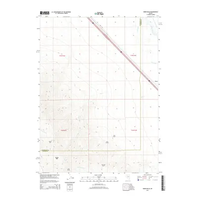
2014 Map of Snow Gulch
USGS Topo · Published 2014About this map
Battle Mtn anchors the high desert landscape of Humboldt and Lander counties in this 2014 survey. The terrain is defined by dramatic elevation changes, where Piute Canyon, Snow Gulch, and Poormans Gulch carve through the mountain slopes. This area reveals a history of industrial and agricultural water management, evidenced by the Dewitt Mill and the Lower Twenty-five Ditch which diverts from the Humboldt River corridor. The northern portion of the map shows the transition from the steep peaks down toward the river basin, where the Reese River and Elder Cr drain into the valley. Modern transportation is represented by Interstate 80 and the Mote Hwy, which cut diagonally across the arid flats, providing a stark contrast to the winding natural watercourses like Little Giant Mill Cr and N Fork Trout Cr found in the higher elevations.
Find a feature on this map
20 named features on this map. Tap any name to fly to it.
Don’t see what you’re looking for? This feature index may not catch every label — zoom into the map to look around manually.
Map Details
Editions of this 2014 Snow Gulch Map
This is the sole edition of this map. No revisions or reprints were ever made.
Other maps of this area

1932 · Sonoma Range
USGS Topo · 1:250,000

1939 · Sonoma Range
USGS Topo · 1:250,000

1940 · Antler Peak
USGS Topo · 1:62,500

1943 · Antler Peak
USGS Topo · 1:62,500

1955 · Winnemucca
USGS Topo · 1:250,000

1957 · Battle Mountain
USGS Topo · 1:62,500

1958 · Winnemucca
USGS Topo · 1:250,000

1962 · Winnemucca
USGS Topo · 1:250,000

1965 · Russells
USGS Topo · 1:24,000
1965 · Valmy
USGS Topo · 1:24,000