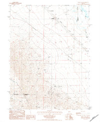
1984 Map of Snow Gulch
USGS Topo · Published 1984About this map
Battle Mountain dominates this landscape on the border of Humboldt and Lander Counties, where the rugged desert terrain meets the crucial water systems of the Humboldt River and Reese River. The map documents an intensive history of mining activity, particularly concentrated along the steep drainage of Snow Gulch and Plute Canyon. Numerous extraction sites like the Bailey Day Mine and DeWitt Mine are recorded alongside numerous unnamed mineshafts and mine tunnels, illustrating the area's role in the regional mineral economy.
Find a feature on this map
25 named features on this map. Tap any name to fly to it.
Don’t see what you’re looking for? This feature index may not catch every label — zoom into the map to look around manually.
Map Details
Editions of this 1984 Snow Gulch Map
This is the sole edition of this map. No revisions or reprints were ever made.
Other maps of this area

1932 · Sonoma Range
USGS Topo · 1:250,000

1939 · Sonoma Range
USGS Topo · 1:250,000

1940 · Antler Peak
USGS Topo · 1:62,500

1943 · Antler Peak
USGS Topo · 1:62,500

1955 · Winnemucca
USGS Topo · 1:250,000

1957 · Battle Mountain
USGS Topo · 1:62,500

1958 · Winnemucca
USGS Topo · 1:250,000

1962 · Winnemucca
USGS Topo · 1:250,000

1965 · Russells
USGS Topo · 1:24,000
1965 · Valmy
USGS Topo · 1:24,000