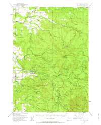
1951 Map of Snow Peak
USGS Topo · Published 1963About this map
Snow Peak and the surrounding timberlands of Linn County define this 1951 landscape, where the foothills of the Cascades meet the valley floor. The map documents a rural infrastructure centered on water and forestry, anchored by the Roaring River State Fish Hatchery and numerous drainage networks like Thomas Creek and Crabtree Creek. For genealogists, the map preserves the exact locations of community centers such as St Benedicts School and its associated Cem, alongside the Lacomb Cemetery further south. The presence of Jordan Dam, various Gravel Pits, and Fords Mill illustrates the local resource-based economy. Higher elevations are marked by the Snow Peak Lookout and Snow Peak Camp, providing a detailed look at fire management and early 1950s mountain access via the Crabtree Guard Sta and Jordan Guard Sta. This survey captures the transition from established valley settlements like Lacomb and East Berlin to the high ridges of Keel Mtn and Rogers Mountain.
Find a feature on this map
69 named features on this map. Tap any name to fly to it.
Don’t see what you’re looking for? This feature index may not catch every label — zoom into the map to look around manually.
Map Details
Editions of this 1951 Snow Peak Map
3 editions found

Other maps of this area

1921 · Brownsville
USGS Topo · 1:62,500

1921 · Lebanon
USGS Topo · 1:62,500

1922 · Lebanon
USGS Topo · 1:48,000

1924 · Lebanon
USGS Topo · 1:62,500

1925 · Stayton
USGS Topo · 1:62,500

1929 · Mill City
USGS Topo · 1:125,000

1934 · Mc Kenzie Bridge
USGS Topo · 1:96,000

1940 · Lebanon
USGS Topo · 1:62,500

1940 · Mc Kenzie Bridge
USGS Topo · 1:125,000

1941 · Stayton
USGS Topo · 1:62,500