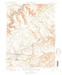
1928 Map of Snow Shoe
USGS Topo · Published 1928About this map
The Pennsylvania Railroad and New York Central Railroad corridor through the West Branch Susquehanna River valley anchors this 1928 survey of the Pennsylvania highlands. The map documents the industrial landscape of the late 1920s, centered on the coal-mining operations at Mine No 26 and Mine No 25 near the settlement of Snow Shoe. This region was then a patchwork of small company towns and infrastructure, including the Clarence Snow Shoe Sta, Glintown, and Pancake.
Find a feature on this map
117 named features on this map. Tap any name to fly to it.
Don’t see what you’re looking for? This feature index may not catch every label — zoom into the map to look around manually.
Map Details
Editions of this 1928 Snow Shoe Map
5 editions found
Other maps of this area

1908 · Bellefonte
USGS Topo · 1:62,500

1909 · Bellefonte
USGS Topo · 1:62,500

1921 · Howard
USGS Topo · 1:48,000

1922 · Philipsburg
USGS Topo · 1:62,500

1923 · Howard
USGS Topo · 1:62,500

1924 · Centre Hall
USGS Topo · 1:62,500

1928 · Snow Shoe
USGS Topo · 1:48,000

1929 · Centre Hall
USGS Topo · 1:62,500

1929 · Karthaus
USGS Topo · 1:62,500

1931 · Show Shoe
USGS Topo · 1:62,500