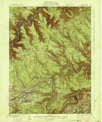
1931 Map of Snow Shoe
USGS Topo · Published 1931About this map
The West Branch Susquehanna River carves a deep, winding path through the northern reaches of this territory, where remote logging and hunting camps like William Penn Camp and Soldiers Home Camp signify the area's recreational and timber-based character. To the south, the landscape shifts toward industrial activity concentrated around the settlements of Snow Shoe and Clarence. This region is defined by its early twentieth-century coal operations, notably Mine No 28 and Mine No 29, which are connected to broader markets by the Pennsylvania Railroad and the New York Central Railroad. Scattered rural education centers like Pancake Sch and Mountain Side Sch serve the small communities nestled between Beech Creek and Moshannon Creek. The map documents a rugged interior of Pennsylvania where the extraction of natural resources and the development of rail infrastructure once dictated the rhythm of local life.
Find a feature on this map
60 named features on this map. Tap any name to fly to it.
Don’t see what you’re looking for? This feature index may not catch every label — zoom into the map to look around manually.
Map Details
Editions of this 1931 Snow Shoe Map
3 editions found
Other maps of this area

1908 · Bellefonte
USGS Topo · 1:62,500

1909 · Bellefonte
USGS Topo · 1:62,500

1921 · Howard
USGS Topo · 1:48,000

1922 · Philipsburg
USGS Topo · 1:62,500

1923 · Howard
USGS Topo · 1:62,500

1924 · Centre Hall
USGS Topo · 1:62,500

1928 · Snow Shoe
USGS Topo · 1:48,000

1929 · Centre Hall
USGS Topo · 1:62,500

1929 · Karthaus
USGS Topo · 1:62,500

1931 · Show Shoe
USGS Topo · 1:62,500