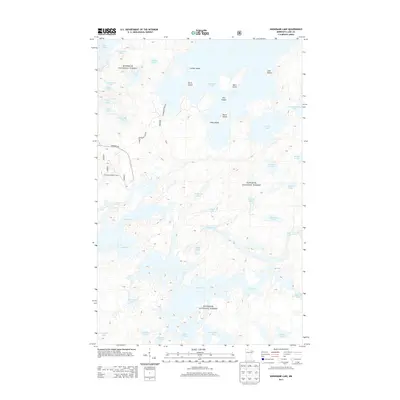
2013 Map of Snowbank Lake
USGS Topo · Published 2013About this map
Superior National Forest encompasses this intricate portion of the Boundary Waters region, defined by a dense network of interconnected waterways and islands. Centered on Snowbank Lake, the landscape is dotted with prominent landforms like Center Island and Birch Island, while the Fernberg Lookout Tower provides a strategic vantage point overlooking the surrounding lakes. The survey captures the transition from road-accessible areas via Snowbank Lake Rd and Fernberg Rd into the more interior, chain-like water systems including Lake One, Lake Three, and Lake Four. These lake chains, often utilized as historic canoe routes, reveal a complex geography of narrow channels and broad basins such as Moose Lake and Disappointment Lake. The presence of Snowbank Lodge Rd indicates local infrastructure supporting the area's long-standing tradition of wilderness recreation and seasonal residency.
Find a feature on this map
44 named features on this map. Tap any name to fly to it.
Don’t see what you’re looking for? This feature index may not catch every label — zoom into the map to look around manually.
Map Details
Editions of this 2013 Snowbank Lake Map
This is the sole edition of this map. No revisions or reprints were ever made.
Other maps of this area

1954 · Two Harbors
USGS Topo · 1:250,000

1957 · Two Harbors
USGS Topo · 1:250,000

1957 · Gabbro Lake
USGS Topo · 1:62,500

1957 · Ensign Lake
USGS Topo · 1:62,500

1957 · Basswood Lake
USGS Topo · 1:62,500

1957 · Quetico
USGS Topo · 1:250,000

1958 · Two Harbors
USGS Topo · 1:250,000

1964 · Two Harbors
USGS Topo · 1:250,000

1968 · Quetico
USGS Topo · 1:250,000
1976 · Basswood Lake SE
USGS Topo · 1:24,000