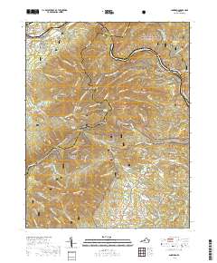
2019 Map of Snowden
USGS Topo · Published 2019About this map
The James River cuts a deep path through the Blue Ridge, creating the dramatic water gap at Balcony Falls where Rockbridge, Bedford, and Amherst Counties converge. This 2019 survey captures the intersection of heavy transport and protected wilderness, showing the Appalachian National Scenic Trail as it winds across Gunter Ridge and past the distinctive Devils Marbleyard. The landscape is dominated by the massive presence of the George Washington National Forest and Jefferson National Forest, split by the river and the Blue Ridge Parkway.
Find a feature on this map
91 named features on this map. Tap any name to fly to it.
Don’t see what you’re looking for? This feature index may not catch every label — zoom into the map to look around manually.
Map Details
Editions of this 2019 Snowden Map
This is the sole edition of this map. No revisions or reprints were ever made.
Other maps of this area

1890 · Roanoke
USGS Topo · 1:125,000

1891 · Roanoke
USGS Topo · 1:125,000

1892 · Lynchburg
USGS Topo · 1:125,000

1894 · Natural Bridge
USGS Topo · 1:125,000

1894 · Lexington
USGS Topo · 1:125,000

1894 · Natural Bridge
USGS Topo · 1:62,500

1907 · Natural Bridge Special
USGS Topo · 1:62,500

1935 · Buena Vista
USGS Topo · 1:48,000

1939 · Buena Vista
USGS Topo · 1:62,500

1940 · Buena Vista
USGS Topo · 1:62,500