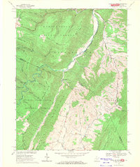
1969 Map of Snowy Mountain
USGS Topo · Published 1971About this map
South Fork Potomac River carves a deep valley through this highland border region, where the state line between West Virginia and Virginia follows the high crest of the Alleghenies. The landscape is defined by the convergence of the Monongahela National Forest and the George Washington National Forest, creating a mosaic of protected timberland and isolated mountain settlements. Small upland communities like Hardscrabble and Dry Run are connected by narrow roads that trace the winding watercourses of Laurel Fork and Straight Fork. The mapping reveals a traditional rural social structure centered on local landmarks such as Elk Mt Chapel, Swank Chapel, and Dry Run Ch, alongside several family-named cemeteries. Notable terrain features including Snowy Mountain, Backbone Mountain, and The Stamp overlook a network of hollows and runs, reflecting a late 1960s snapshot of West Virginia’s ridge-and-valley topography before modern development.
Find a feature on this map
45 named features on this map. Tap any name to fly to it.
Don’t see what you’re looking for? This feature index may not catch every label — zoom into the map to look around manually.
Map Details
Editions of this 1969 Snowy Mountain Map
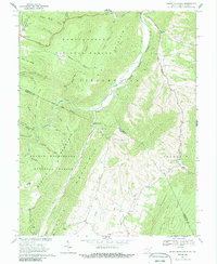
2 editions found
Other maps of this area

1889 · Beverly
USGS Topo · 1:125,000

1892 · Beverly
USGS Topo · 1:125,000

1892 · Franklin
USGS Topo · 1:125,000

1894 · Staunton
USGS Topo · 1:125,000

1896 · Franklin
USGS Topo · 1:125,000

1901 · Monterey
USGS Topo · 1:125,000

1922 · Spruce Knob
USGS Topo · 1:48,000

1922 · Circleville
USGS Topo · 1:62,500

1924 · Circleville
USGS Topo · 1:48,000

1924 · Mc Dowell
USGS Topo · 1:62,500