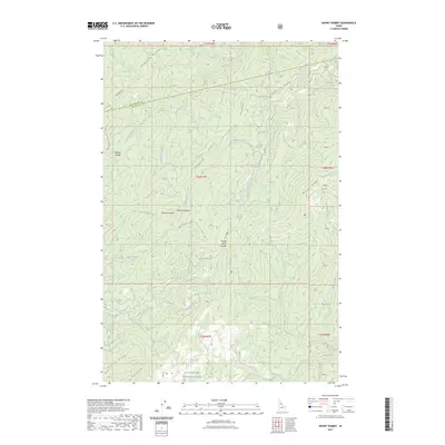
2023 Map of Snowy Summit
USGS Topo · Published 2023About this map
Clearwater National Forest encompasses this high-elevation terrain, where steep drainages and prominent ridges define the landscape near the border of Clearwater Co and Idaho Co. The map area is punctuated by significant landmarks like Snowy Summit and the high-altitude Soldier Meadows. A complex network of Forest Service roads, such as Nat For Dev Rd 104, provides access to these remote areas, which were historically traversed via routes like the Lolo Trl. Hydrological features are abundant, with numerous waterways including Hemlock Creek, Hungry Creek, and Middle Creek carving through the mountain system. The presence of named saddles like Beaver Saddle and Beaver Dam Saddle indicates the topography's influence on movement through the Hemlock Ridge and Rocky Ridge areas.
Find a feature on this map
40 named features on this map. Tap any name to fly to it.
Don’t see what you’re looking for? This feature index may not catch every label — zoom into the map to look around manually.
Map Details
Editions of this 2023 Snowy Summit Map
This is the sole edition of this map. No revisions or reprints were ever made.
Other maps of this area

1911 · Lolo
USGS Topo · 1:250,000

1913 · Lolo
USGS Topo · 1:250,000

1923 · Washington Creek
USGS Topo · 1:125,000

1924 · Weippe
USGS Topo · 1:125,000

1956 · Hamilton
USGS Topo · 1:250,000

1959 · Hamilton
USGS Topo · 1:250,000

1960 · Hamilton
USGS Topo · 1:250,000

1964 · Hamilton
USGS Topo · 1:250,000

1965 · Lean-to Point
USGS Topo · 1:24,000
1965 · Larch Butte
USGS Topo · 1:24,000