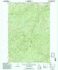
1994 Map of Snowy Summit
USGS Topo · Published 1997About this map
Nez Perce National Historic Trail and the Lewis and Clark National Historic Trail trace a shared corridor through the center of this high-elevation landscape, following the long spines of Hemlock Ridge and Leanto Ridge. This mid-1990s revision by the U.S. Forest Service captures a wilderness area defined by its hydrology and strategic travel routes, where the Pierce Ranger District and Lochsa Ranger District meet. Settlement is entirely absent, replaced by specialized forest landmarks such as Footrot Corrals and remote outposts like Savage Camp and Camp Martin. The topography is dominated by the steep drainage basins of the Middle Fork Clearwater River, with numerous named streams like Hungery Creek and Eldorado Creek cutting through the ridges. Campsites with distinctive names, including Horsesteak Meadow Camp and Jerusalem Artichoke Campsite, highlight the area's continued use for backcountry exploration.
Find a feature on this map
35 named features on this map. Tap any name to fly to it.
Don’t see what you’re looking for? This feature index may not catch every label — zoom into the map to look around manually.
Map Details
Editions of this 1994 Snowy Summit Map
This is the sole edition of this map. No revisions or reprints were ever made.
Other maps of this area

1911 · Lolo
USGS Topo · 1:250,000

1913 · Lolo
USGS Topo · 1:250,000

1923 · Washington Creek
USGS Topo · 1:125,000

1924 · Weippe
USGS Topo · 1:125,000

1956 · Hamilton
USGS Topo · 1:250,000

1959 · Hamilton
USGS Topo · 1:250,000

1960 · Hamilton
USGS Topo · 1:250,000

1964 · Hamilton
USGS Topo · 1:250,000

1965 · Lean-to Point
USGS Topo · 1:24,000
1965 · Larch Butte
USGS Topo · 1:24,000