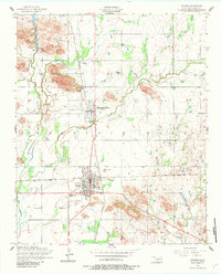
1956 Map of Snyder
USGS Topo · Published 1983About this map
Snyder and Mountain Park serve as the primary hubs in this mid-century Oklahoma landscape, situated where the St Louis San Francisco railroad lines converge. The terrain is defined by the prominent granite rises of the Mountain Park area, which contrast sharply with the surrounding agricultural plains. Water management for these communities is evident through Snyder Lake in the northwest, supported by a pumping station, filtration beds, and a water tank.
Find a feature on this map
64 named features on this map. Tap any name to fly to it.
Don’t see what you’re looking for? This feature index may not catch every label — zoom into the map to look around manually.
Map Details
Editions of this 1956 Snyder Map
2 editions found
Other maps of this area

1949 · Cooperton
USGS Topo · 1:62,500

1950 · Snyder
USGS Topo · 1:62,500

1955 · Lawton
USGS Topo · 1:250,000

1956 · Glen Mountains
USGS Topo · 1:24,000

1956 · Cooperton
USGS Topo · 1:24,000

1956 · Odetta
USGS Topo · 1:24,000

1956 · Manitou
USGS Topo · 1:24,000

1956 · Snyder
USGS Topo · 1:24,000

1956 · Indiahoma
USGS Topo · 1:24,000

1956 · Snyder
USGS Topo · 1:62,500