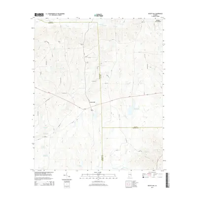
2014 Map of Society Hill
USGS Topo · Published 2014About this map
Society Hill serves as the central hub of this East Alabama landscape, situated where the borders of Macon, Lee, and Russell Counties converge. This 2014 survey reveals a region deeply rooted in its local heritage, evidenced by the high density of family-named burial sites such as Herbert Brown Cem, Cobbs Cem, Whatley Cem, and Holt Cem. These landmarks, alongside Saint Paul Cem, offer critical data points for genealogists tracing ancestral lines through the rural South. The topography is defined by an intricate network of waterways including Opintlocco Cr, Uchee Cr, and Long Br, which snake between low ridges and feed numerous private impoundments like Kellys Pond Number One and Talbert Lake. The intersection of modern infrastructure with historic paths is visible at Whatley Cross Road and along the various county routes that crisscross the agricultural and wooded terrain.
Find a feature on this map
70 named features on this map. Tap any name to fly to it.
Don’t see what you’re looking for? This feature index may not catch every label — zoom into the map to look around manually.
Map Details
Editions of this 2014 Society Hill Map
This is the sole edition of this map. No revisions or reprints were ever made.
Other maps of this area

1906 · Dadeville
USGS Topo · 1:125,000

1907 · Opelika
USGS Topo · 1:125,000

1909 · Opelika
USGS Topo · 1:125,000

1955 · Phenix City
USGS Topo · 1:250,000

1957 · Phenix City
USGS Topo · 1:250,000

1958 · Phenix City
USGS Topo · 1:250,000

1971 · Parkers Crossroads
USGS Topo · 1:24,000

1971 · Little Texas
USGS Topo · 1:24,000

1971 · Loachapoka
USGS Topo · 1:24,000
1971 · Marvyn
USGS Topo · 1:24,000