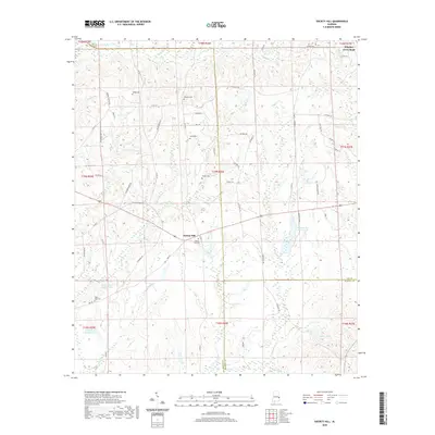
2020 Map of Society Hill
USGS Topo · Published 2020About this map
Society Hill serves as a central point in this part of Macon and Lee counties, where rural land patterns are defined by a network of creeks and family cemeteries. Small, localized burial grounds like Cobbs Cem, Whatley Cem, and Holt Cem are scattered across the landscape, providing essential clues for genealogists tracking early families in the area. The terrain is deeply carved by water, with Opintlocco Cr and Uchee Cr creating a complex drainage system that influenced road placement and property lines. To the north, Whatley Cross Road marks a historic junction, while the presence of Engineering Farm Pond and Talbert Lake reflects the managed water resources of the modern era. The map documents a quiet, traditional Alabama landscape where rural routes like Old Columbus Rd and Co Rd 43 connect long-standing homesteads and communal landmarks such as Saint Paul Cem.
Find a feature on this map
73 named features on this map. Tap any name to fly to it.
Don’t see what you’re looking for? This feature index may not catch every label — zoom into the map to look around manually.
Map Details
Editions of this 2020 Society Hill Map
This is the sole edition of this map. No revisions or reprints were ever made.
Other maps of this area

1906 · Dadeville
USGS Topo · 1:125,000

1907 · Opelika
USGS Topo · 1:125,000

1909 · Opelika
USGS Topo · 1:125,000

1955 · Phenix City
USGS Topo · 1:250,000

1957 · Phenix City
USGS Topo · 1:250,000

1958 · Phenix City
USGS Topo · 1:250,000

1971 · Parkers Crossroads
USGS Topo · 1:24,000

1971 · Little Texas
USGS Topo · 1:24,000

1971 · Loachapoka
USGS Topo · 1:24,000
1971 · Marvyn
USGS Topo · 1:24,000