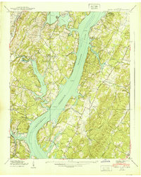
1939 Map of Soddy Island
USGS Topo · Published 1939About this map
Chickamauga Reservoir dominates this 1939 survey, illustrating the dramatic transformation of the Tennessee River valley during the Tennessee Valley Authority's infrastructure expansion. The map captures the intricate shoreline where the rising waters met the mouths of Sale Creek, Possum Creek, and Soddy Creek, effectively reshaping the local geography just before the new reservoir was fully realized.
Find a feature on this map
49 named features on this map. Tap any name to fly to it.
Don’t see what you’re looking for? This feature index may not catch every label — zoom into the map to look around manually.
Map Details
Editions of this 1939 Soddy Island Map
4 editions found
Other maps of this area

1886 · Cleveland
USGS Topo · 1:125,000

1888 · Chattanooga
USGS Topo · 1:125,000

1892 · Cleveland
USGS Topo · 1:125,000

1893 · Chattanooga
USGS Topo · 1:125,000

1895 · Cleveland
USGS Topo · 1:125,000

1901 · Cleveland
USGS Topo · 1:125,000

1935 · Daisy
USGS Topo · 1:24,000

1935 · Soddy
USGS Topo · 1:24,000

1935 · Snow Hill
USGS Topo · 1:24,000

1935 · Brayton
USGS Topo · 1:24,000