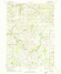
1970 Map of Sodus
USGS Topo · Published 1973About this map
Sodus and several other small farming hubs define the Berrien County landscape at the turn of the 1970s. The region is marked by its numerous hamlets and crossroads, including Millburg, Pearl Grange, and Shanghai Corners. A distinct grid of township roads—such as Napier Ave, Edwards Road, and Watson Road—segments the countryside, which is heavily shaped by agricultural and local drainage patterns. Significant water bodies like Mills Lake, Black Lake, and Mud Lake are interspersed with smaller marshlands and tributaries.
Find a feature on this map
46 named features on this map. Tap any name to fly to it.
Don’t see what you’re looking for? This feature index may not catch every label — zoom into the map to look around manually.
Map Details
Editions of this 1970 Sodus Map
This is the sole edition of this map. No revisions or reprints were ever made.
Other maps of this area

1927 · Niles
USGS Topo · 1:62,500

1927 · Hartford
USGS Topo · 1:62,500

1927 · Benton Harbor
USGS Topo · 1:62,500

1930 · Benton Harbor
USGS Topo · 1:62,500

1930 · Niles
USGS Topo · 1:62,500

1931 · Hartford
USGS Topo · 1:62,500

1943 · Niles
USGS Topo · 1:62,500

1945 · Cassopolis
USGS Topo · 1:62,500

1947 · Cassopolis
USGS Topo · 1:62,500

1953 · Chicago
USGS Topo · 1:250,000