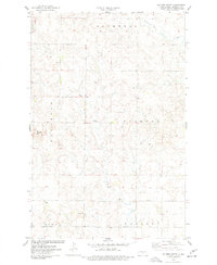
1975 Map of Solberg Butte
USGS Topo · Published 1977About this map
Swedish Cem serves as a silent witness to the early Scandinavian settlers in this part of Burleigh County, positioned just north of the Naughton settlement. The landscape is defined by the high point of Solberg Butte and the winding course of the West Branch Apple Creek in the northeast. This 1970s land survey illustrates a rural economy centered on agriculture and resource extraction, evidenced by several Gravel Pits scattered across the township lines of Cromwell, Frances, Gibbs, and Menoken. The map includes many section lines and fence markings that reflect the systematic division of North Dakota's prairie into family farmsteads and organized townships like Crofte.
Find a feature on this map
13 named features on this map. Tap any name to fly to it.
Don’t see what you’re looking for? This feature index may not catch every label — zoom into the map to look around manually.
Map Details
Editions of this 1975 Solberg Butte Map
This is the sole edition of this map. No revisions or reprints were ever made.
Other maps of this area

1907 · Bismarck
USGS Topo · 1:125,000

1951 · Menoken SW
USGS Topo · 1:24,000

1951 · Menoken
USGS Topo · 1:62,500

1951 · McKenzie
USGS Topo · 1:62,500

1954 · Bismarck
USGS Topo · 1:250,000

1954 · McClusky
USGS Topo · 1:250,000

1958 · Bismarck
USGS Topo · 1:250,000

1958 · McClusky
USGS Topo · 1:250,000

1962 · Menoken SW
USGS Topo · 1:24,000

1975 · McKenzie
USGS Topo · 1:24,000