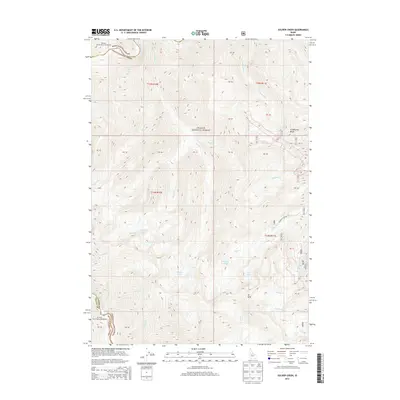
2013 Map of Soldier Creek
USGS Topo · Published 2013About this map
Josephus Lake Rd provides the primary access route into this high-elevation backcountry where the Valley and Custer county lines meet. The terrain is defined by the high crests of Greyhound Ridge and Mt Mills, which separate numerous alpine basins containing named water bodies such as Josephus Lake, Helldiver Lake, and the Soldier Lakes. This area of the Challis National Forest and Boise National Forest is characterized by a dense network of drainages, including Soldier Cr and Greyhound Cr, which flow toward the Middle Fork Salmon River in the northwest corner. The map captures the remote wilderness character of the Salmon River Mountains, showing no permanent settlements but highlighting numerous topographical features like Cutthroat Lake and Lost Lake that serve as vital landmarks for modern backcountry navigation and historical land use studies.
Find a feature on this map
30 named features on this map. Tap any name to fly to it.
Don’t see what you’re looking for? This feature index may not catch every label — zoom into the map to look around manually.
Map Details
Editions of this 2013 Soldier Creek Map
This is the sole edition of this map. No revisions or reprints were ever made.
Other maps of this area

1891 · Bear Valley
USGS Topo · 1:125,000

1893 · Bear Valley
USGS Topo · 1:125,000

1957 · Challis
USGS Topo · 1:250,000

1960 · Challis
USGS Topo · 1:250,000

1961 · Greyhound Ridge
USGS Topo · 1:62,500

1961 · Chinook Mtn
USGS Topo · 1:62,500

1963 · Challis
USGS Topo · 1:250,000
1972 · Langer Peak
USGS Topo · 1:24,000
1972 · Blue Bunch Mtn
USGS Topo · 1:24,000
1972 · Cape Horn Lakes
USGS Topo · 1:24,000