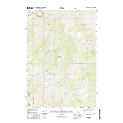
2017 Map of Soldier Creek
USGS Topo · Published 2017About this map
The Middle Fork Salmon River cuts through the northwestern corner of this high-elevation terrain, marking the boundary between Valley and Custer counties. This landscape is defined by the high divides of Soldier Ridge and Greyhound Ridge, which cradle a high-mountain lake system including Soldier Lakes, Iris Lake, and the remote Helldiver Lake. The map reveals a complex drainage network where Soldier Creek and Muskeg Creek flow through the heart of the Challis National Forest. Notable landmarks such as Mt Mills and the high-altitude Josephus Lake highlight the primary points of interest for backcountry researchers. The presence of the Josephus Lake Rd provides one of the few designated access points into this primitive area, contrasting with the numerous unnamed trails and creek beds like Float Cr and Sulphur Creek.
Find a feature on this map
38 named features on this map. Tap any name to fly to it.
Don’t see what you’re looking for? This feature index may not catch every label — zoom into the map to look around manually.
Map Details
Editions of this 2017 Soldier Creek Map
This is the sole edition of this map. No revisions or reprints were ever made.
Other maps of this area

1891 · Bear Valley
USGS Topo · 1:125,000

1893 · Bear Valley
USGS Topo · 1:125,000

1957 · Challis
USGS Topo · 1:250,000

1960 · Challis
USGS Topo · 1:250,000

1961 · Greyhound Ridge
USGS Topo · 1:62,500

1961 · Chinook Mtn
USGS Topo · 1:62,500

1963 · Challis
USGS Topo · 1:250,000
1972 · Langer Peak
USGS Topo · 1:24,000
1972 · Blue Bunch Mtn
USGS Topo · 1:24,000
1972 · Cape Horn Lakes
USGS Topo · 1:24,000