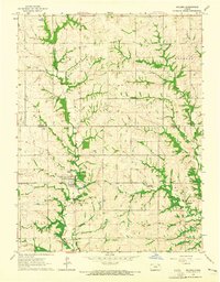
1964 Map of Soldier
USGS Topo · Published 1965About this map
Soldier stands as the primary hub in this mid-1960s landscape, positioned near the confluence of local drainage systems including Soldier Creek and Elk Creek. The town is characterized by essential community infrastructure, including a local High Sch, a Cem, and a prominent Water Tank. A distinctive diagonal line through the southern townships indicates an Old Railroad Grade, showing the transition from rail-based transportation to a post-rail era. The surrounding townships of Reilly, Wetmore, and Jefferson are marked by a series of creeks, such as Mosquito Creek, and small-scale industrial sites like a Quarry and Gravel Pit. The map captures the interface between Nemaha and Jackson Counties, highlighting small rural settlements like Bancroft and Ontario during a period when agrarian patterns remained the dominant feature of the Northeast Kansas countryside.
Find a feature on this map
18 named features on this map. Tap any name to fly to it.
Don’t see what you’re looking for? This feature index may not catch every label — zoom into the map to look around manually.
Map Details
Editions of this 1964 Soldier Map
This is the sole edition of this map. No revisions or reprints were ever made.
Other maps of this area

1888 · Hiawatha
USGS Topo · 1:125,000

1889 · Seneca
USGS Topo · 1:125,000

1889 · Wamego
USGS Topo · 1:125,000

1889 · Topeka
USGS Topo · 1:125,000

1894 · Seneca
USGS Topo · 1:125,000

1894 · Topeka
USGS Topo · 1:125,000

1894 · Hiawatha
USGS Topo · 1:125,000

1894 · Wamego
USGS Topo · 1:125,000

1950 · Kansas City
USGS Topo · 1:250,000

1954 · Kansas City
USGS Topo · 1:250,000