
1910 Map of Soledad
USGS Topo · Published 1910About this map
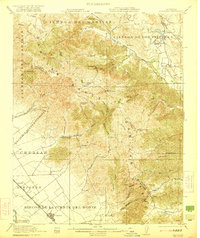
The Salinas River winds through this 1910 landscape, flanked by the sprawling Mexican land grants that defined Monterey County's early property lines. The presence of Ex Mission Soledad anchors the southern portion of the sheet, reflecting the area's transition from Spanish mission lands to an established agricultural corridor. Irrigation patterns and road networks are concentrated between the river and the steep northern hills, illustrating how the geography dictated the layout of early ranching and farming operations.
Find a feature on this map
9 named features on this map. Tap any name to fly to it.
Don’t see what you’re looking for? This feature index may not catch every label — zoom into the map to look around manually.
Map Details
Editions of this 1910 Soledad Map
This is the sole edition of this map. No revisions or reprints were ever made.
Other maps of this area

1910 · Gonzales
USGS Topo · 1:31,680

1910 · Salinas
USGS Topo · 1:31,680

1912 · Salinas
USGS Topo · 1:62,500

1915 · Soledad
USGS Topo · 1:62,500

1920 · Jamesburg
USGS Topo · 1:48,000

1921 · Jamesburg
USGS Topo · 1:62,500
1921 · Gonzales
USGS Topo · 1:62,500

1939 · Jamesburg
USGS Topo · 1:62,500

1940 · Salinas
USGS Topo · 1:62,500

1940 · Jamesburg
USGS Topo · 1:62,500