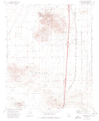
1973 Map of Soledad Mtn
USGS Topo · Published 1976About this map
Golden Queen Mine and the Bobtail Mines anchor the northern slopes of Soledad Mountain, highlighting an active industrial landscape of extraction in this part of Kern County. The map details a complex network of mining operations, from the Tropico Shaft near Tropico Hill to various Quarries, Borrow Pits, and a Claypit. These industrial features sit in stark contrast to the small residential pockets like Hidden Valley and the Trailer Park to the west.
Find a feature on this map
34 named features on this map. Tap any name to fly to it.
Don’t see what you’re looking for? This feature index may not catch every label — zoom into the map to look around manually.
Map Details
Editions of this 1973 Soledad Mtn Map
This is the sole edition of this map. No revisions or reprints were ever made.
Other maps of this area

1915 · Elizabeth Lake
USGS Topo · 1:125,000

1915 · Mojave
USGS Topo · 1:125,000

1917 · Elizabeth Lake
USGS Topo · 1:125,000

1943 · Rosamond
USGS Topo · 1:62,500

1943 · Tehachapi
USGS Topo · 1:62,500

1943 · Mojave
USGS Topo · 1:62,500

1943 · Willow Springs
USGS Topo · 1:62,500
1947 · Rosamond
USGS Topo · 1:24,000

1947 · Plano
USGS Topo · 1:24,000

1947 · Mojave
USGS Topo · 1:24,000