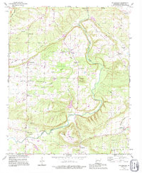
1990 Map of Solgohachia
USGS Topo · Published 1995About this map
Point Remove Creek and its eastern fork define the drainage of this central Arkansas landscape, where small agricultural communities are scattered between prominent ridges. The topography is dominated by local landmarks such as Pigeon Roost Mountain and Bull Mountain, which dictated the early settlement patterns of the 19th and 20th centuries. This 1990 revision shows the persistence of rural hamlets like Saint Vincent and Solgohachia, each anchored by historical institutions. Genealogists will find a high density of burial sites, including St Marys Cem, Middleton Cem, and Friendship Cem, often situated near country churches like Vinson Chapel or Wesley Chapel. The presence of a Landing Strip and a Gravel Pit indicates the modest local infrastructure supporting the area's timber and agricultural economy during the late 20th century.
Find a feature on this map
51 named features on this map. Tap any name to fly to it.
Don’t see what you’re looking for? This feature index may not catch every label — zoom into the map to look around manually.
Map Details
Editions of this 1990 Solgohachia Map
This is the sole edition of this map. No revisions or reprints were ever made.
Other maps of this area

1889 · Morrilton No. 3
USGS Topo · 1:62,500

1892 · Morrillton
USGS Topo · 1:125,000

1894 · Morrillton
USGS Topo · 1:125,000

1956 · Russellville
USGS Topo · 1:250,000

1961 · Menifee
USGS Topo · 1:24,000

1961 · Morrilton East
USGS Topo · 1:24,000

1961 · Morrilton West
USGS Topo · 1:24,000
1962 · Jerusalem
USGS Topo · 1:24,000
1962 · Cleveland
USGS Topo · 1:24,000
1962 · Solgohachia
USGS Topo · 1:24,000