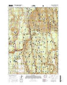
2017 Map of Soloman Butte
USGS Topo · Published 2017About this map
The Williamson River winds through the high desert and forest transition of Klamath County, anchoring a landscape defined by volcanic landforms and managed timberlands. In the northern reaches of the Winema National Forest, the small settlement of Kirk sits near the river's bend, historically serving as a rail and ranching point. The terrain is punctuated by significant rises such as Soloman Butte and Spring Hill, which overlook a network of forest service roads including Nat For Dev Rd 9734 and the Kirk - Broy Mill Rd. Numerous water sources like Merritt Spring, Buckeroo Spring, and the Hilltop Reservoir indicate the vital importance of water management for local ecosystems and land use. To the south, residential development near Larkin Cr is visible through modern street names such as Sunnybrook Rd and Cowboy Hill Ln.
Find a feature on this map
28 named features on this map. Tap any name to fly to it.
Don’t see what you’re looking for? This feature index may not catch every label — zoom into the map to look around manually.
Map Details
Editions of this 2017 Soloman Butte Map
This is the sole edition of this map. No revisions or reprints were ever made.
Other maps of this area

1889 · Klamath
USGS Topo · 1:250,000

1894 · Klamath
USGS Topo · 1:250,000

1955 · Klamath Falls
USGS Topo · 1:250,000

1956 · Calimus Butte
USGS Topo · 1:62,500

1957 · Chiloquin
USGS Topo · 1:62,500

1957 · Klamath Marsh
USGS Topo · 1:62,500

1957 · Lenz
USGS Topo · 1:62,500

1958 · Klamath Falls
USGS Topo · 1:250,000

1980 · Williamson River
USGS Topo · 1:100,000
1985 · Agency Lake
USGS Topo · 1:24,000