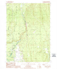
1988 Map of Soloman Butte
USGS Topo · Published 1988About this map
The Williamson River carves a central path through this section of the Winema National Forest, serving as the primary geographic corridor for both natural features and human infrastructure. In the late 1980s, the small settlement of Kirk sits at the northern edge of this quadrangle, positioned near the river where it transitions from open meadows into more timbered terrain. To the south, the preservation of this landscape is evidenced by the convergence of the Sun Pass State Forest and Collier Memorial State Park. Recreational development is concentrated along the water, with the Williamson River Campground and Ouxkanee Picnic Area providing access to the riverbank. This map documents a working forest and protected wilderness, where utilitarian features like a wooden pole trans line and a pipeline traverse the same land as prominent landmarks like Soloman Butte and Buckeroo Spring.
Find a feature on this map
24 named features on this map. Tap any name to fly to it.
Don’t see what you’re looking for? This feature index may not catch every label — zoom into the map to look around manually.
Map Details
Editions of this 1988 Soloman Butte Map
This is the sole edition of this map. No revisions or reprints were ever made.
Other maps of this area

1889 · Klamath
USGS Topo · 1:250,000

1894 · Klamath
USGS Topo · 1:250,000

1955 · Klamath Falls
USGS Topo · 1:250,000

1956 · Calimus Butte
USGS Topo · 1:62,500

1957 · Chiloquin
USGS Topo · 1:62,500

1957 · Klamath Marsh
USGS Topo · 1:62,500

1957 · Lenz
USGS Topo · 1:62,500

1958 · Klamath Falls
USGS Topo · 1:250,000

1980 · Williamson River
USGS Topo · 1:100,000
1985 · Agency Lake
USGS Topo · 1:24,000