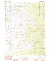
1983 Map of Solomons Temple
USGS Topo · Published 1983About this map
Klamath National Forest defines the eastern half of this 1980s landscape, where the rugged terrain transitions into the high drainage of the Little Shasta River. The topography is characterized by distinctive geological markers like Solomons Temple and Temple Rock, which stand as significant high points above the deeply incised Fogg Gulch and Walbridge Gulch. This period of the early 1980s shows a landscape utilized for both forest management and aviation, evidenced by the Landing Strip located on the valley floor.
Find a feature on this map
27 named features on this map. Tap any name to fly to it.
Don’t see what you’re looking for? This feature index may not catch every label — zoom into the map to look around manually.
Map Details
Editions of this 1983 Solomons Temple Map
This is the sole edition of this map. No revisions or reprints were ever made.
Other maps of this area

1886 · Shasta
USGS Topo · 1:250,000

1894 · Shasta
USGS Topo · 1:250,000

1921 · Shasta Valley Sheet No 11
USGS Topo · 1:24,000

1922 · Shasta Valley Sheet No 10 E
USGS Topo · 1:24,000

1922 · Shasta Valley Sheet No 12
USGS Topo · 1:24,000

1934 · Macdoel
USGS Topo · 1:96,000

1941 · Macdoel
USGS Topo · 1:125,000

1948 · Weed
USGS Topo · 1:250,000

1950 · Weed
USGS Topo · 1:250,000

1954 · The Whaleback
USGS Topo · 1:62,500