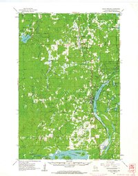
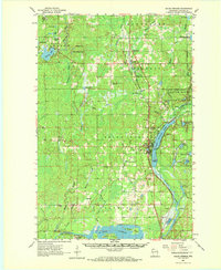
1961 Map of Solon Springs
USGS Topo · Published 1963About this map
Solon Springs serves as the focal point of this northern Wisconsin landscape, situated along the western shore of Upper St Croix Lake. The community is deeply tied to the surrounding Brule River State Forest and the recreational legacy of Lucius Woods State Park. The transportation geography is dominated by the Chicago and North Western railroad, which parallels the lake and connects smaller settlements like Bennett and Beebe. This 1961 survey captures the area before modern development, showing a land defined by water and timber, from the Gordon Flowage in the south to the Amnicon River headwaters in the north. Local history is preserved in sites like Evergreen Cem and the Bennett Lookout Tower, while industrial activity is noted at the Sauntry Gravel Pit.
Find a feature on this map
74 named features on this map. Tap any name to fly to it.
Don’t see what you’re looking for? This feature index may not catch every label — zoom into the map to look around manually.
Map Details
Editions of this 1961 Solon Springs Map
2 editions found
Other maps of this area

1915 · Superior
USGS Topo · 1:48,000

1917 · Superior
USGS Topo · 1:62,500

1945 · Highland
USGS Topo · 1:48,000

1945 · Solon Springs
USGS Topo · 1:48,000

1947 · Brule
USGS Topo · 1:48,000

1947 · Chittamo
USGS Topo · 1:48,000

1947 · Minong
USGS Topo · 1:48,000

1949 · Solon Springs
USGS Topo · 1:48,000

1949 · Chittamo
USGS Topo · 1:48,000

1949 · Minong
USGS Topo · 1:48,000