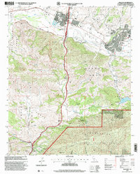
1995 Map of Solvang
USGS Topo · Published 2000About this map
Mission Santa Ines serves as a cultural anchor for this portion of the Santa Ynez Valley, where Spanish land grant legacies meet modern ranching and tourism. The map illustrates a complex landscape of historic tracts, including the San Carlos De Jonata Grant and Nojoqui Grant, which dictate the spatial arrangement of the region's agricultural and residential development. In the north, Solvang and Buellton appear as established hubs along the Santa Ynez River, while the southern reaches transition into the steep elevations of the Los Padres National Forest. Local landmarks like Hans Christian Andersen Park and several prominent estates, such as Alisal Ranch and Folded Hills Ranch, highlight the area's dual identity as a working ranching landscape and a recreational destination. Traces of early transit and settlement are visible at Las Cruces, situated near the confluence of Nojoqui Creek and Canada de las Cruces.
Find a feature on this map
41 named features on this map. Tap any name to fly to it.
Don’t see what you’re looking for? This feature index may not catch every label — zoom into the map to look around manually.
Map Details
Editions of this 1995 Solvang Map
This is the sole edition of this map. No revisions or reprints were ever made.
Other maps of this area

1905 · Lompoc
USGS Topo · 1:125,000

1942 · Lompoc
USGS Topo · 1:125,000

1942 · Lompoc
USGS Topo · 1:62,500

1942 · Pt. Conception
USGS Topo · 1:62,500

1942 · Gaviota
USGS Topo · 1:62,500

1942 · Los Olivos
USGS Topo · 1:62,500

1943 · Los Olivos
USGS Topo · 1:62,500

1943 · Lompoc
USGS Topo · 1:125,000

1943 · Gaviota
USGS Topo · 1:62,500

1947 · Gaviota
USGS Topo · 1:62,500