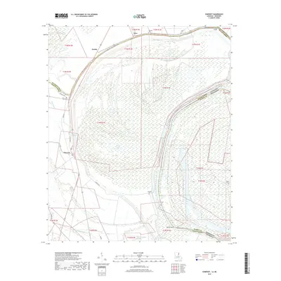
2018 Map of Somerset
USGS Topo · Published 2018About this map
Palmyra Bend and the surrounding river bottomlands define this geography where the borders of Louisiana and Mississippi intertwine. This 2018 survey documents a landscape of intricate hydrology, featuring the massive oxbow of Palmyra Lake and the Roundaway-Bayou Vidal Cutoff which marks the northern boundary of the quadrangle. Small settlements such as Somerset, Quimby, and Afton are situated along the elevated corridors of the floodplain, often adjacent to local bayous like Mill Bayou and Negro Bayou. The map is particularly useful for genealogists, as it preserves the locations of several small burial sites, including Somerset Cem, Saint John Cem, and Snyder Cem. These sites, along with the distinct property lines of the Public Land Survey System, reveal the pattern of agricultural development and land ownership that has persisted in the Tensas and Madison Parish regions.
Find a feature on this map
34 named features on this map. Tap any name to fly to it.
Don’t see what you’re looking for? This feature index may not catch every label — zoom into the map to look around manually.
Map Details
Editions of this 2018 Somerset Map
This is the sole edition of this map. No revisions or reprints were ever made.
Other maps of this area

1909 · Mound
USGS Topo · 1:24,000

1910 · Mound
USGS Topo · 1:31,680

1935 · Waverly
USGS Topo · 1:62,500

1935 · Shackleford Lake
USGS Topo · 1:62,500

1939 · Talla Bena
USGS Topo · 1:62,500

1955 · Jackson
USGS Topo · 1:250,000

1958 · Shackleford Lake
USGS Topo · 1:62,500

1961 · Jackson
USGS Topo · 1:250,000

1961 · Waverly
USGS Topo · 1:62,500

1962 · Jackson
USGS Topo · 1:250,000