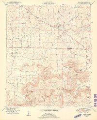
1951 Map of Somerville
USGS Topo · Published 1951About this map
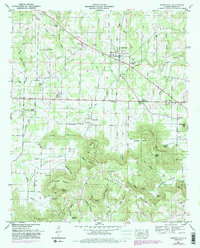
Somerville stands as the central hub of this northern Alabama landscape, situated atop a plateau that drops sharply into the surrounding hollows and springs. The town is marked by its community institutions, including the Somerville School and Ward Chapel, with the nearby Campbell Cem and Northern Spring serving as focal points for local history. To the south, the terrain becomes increasingly complex as the flat agricultural lands give way to the prominent ridges of Brindley Mountain and Fairview Mountain, separated by the steep drainage of Brindley Hollow.
Find a feature on this map
85 named features on this map. Tap any name to fly to it.
Don’t see what you’re looking for? This feature index may not catch every label — zoom into the map to look around manually.
Map Details
Editions of this 1951 Somerville Map
5 editions found
Other maps of this area

1888 · Cullman
USGS Topo · 1:125,000

1888 · Huntsville
USGS Topo · 1:125,000

1892 · Cullman
USGS Topo · 1:125,000

1892 · Huntsville
USGS Topo · 1:125,000

1927 · Falkville
USGS Topo · 1:24,000

1936 · Triana
USGS Topo · 1:24,000

1936 · Hartselle
USGS Topo · 1:24,000

1936 · Decatur
USGS Topo · 1:24,000

1936 · Eva
USGS Topo · 1:24,000

1936 · Somerville
USGS Topo · 1:24,000