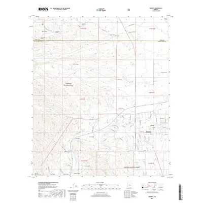
2018 Map of Sonoita
USGS Topo · Published 2018About this map
Sonoita serves as a central hub for this portion of Santa Cruz County, situated at the junction where Old Sonita Hwy meets several rural routes leading toward the Coronado National Forest. The landscape is defined by its drainage patterns, with the Sonita Cr winding through a terrain carved by numerous gulches and canyons such as Boston Gulch and Little Fish Canyon. The settlement of Hacienda Los Encino marks the local residential development, while the northern reaches transition into more isolated territory near the Pima County line.
Find a feature on this map
75 named features on this map. Tap any name to fly to it.
Don’t see what you’re looking for? This feature index may not catch every label — zoom into the map to look around manually.
Map Details
Editions of this 2018 Sonoita Map
This is the sole edition of this map. No revisions or reprints were ever made.
Other maps of this area

1904 · Patagonia
USGS Topo · 1:125,000

1905 · Patagonia
USGS Topo · 1:125,000

1922 · Agus Caliente
USGS Topo · 1:62,500

1926 · Helvetia
USGS Topo · 1:62,500

1932 · Elgin
USGS Topo · 1:62,500

1940 · Elgin
USGS Topo · 1:62,500

1947 · Elgin
USGS Topo · 1:62,500

1948 · Elgin
USGS Topo · 1:24,000

1948 · Sonoita
USGS Topo · 1:24,000
1948 · O'Donnell Canyon
USGS Topo · 1:24,000