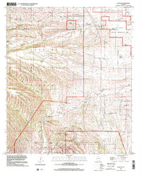
1996 Map of Sonoita
USGS Topo · Published 2002About this map
Fort Crittenden and Fort Buchanan anchor the historical landscape of this region along the upper reaches of Sonoita Creek. Located at the intersection of the Coronado National Forest and the Las Cienegas National Conservation Area, the terrain is defined by a deep network of drainage systems including Gardner Canyon, Adobe Canyon, and Smith Canyon.
Find a feature on this map
36 named features on this map. Tap any name to fly to it.
Don’t see what you’re looking for? This feature index may not catch every label — zoom into the map to look around manually.
Map Details
Editions of this 1996 Sonoita Map
This is the sole edition of this map. No revisions or reprints were ever made.
Other maps of this area

1904 · Patagonia
USGS Topo · 1:125,000

1905 · Patagonia
USGS Topo · 1:125,000

1922 · Agus Caliente
USGS Topo · 1:62,500

1926 · Helvetia
USGS Topo · 1:62,500

1932 · Elgin
USGS Topo · 1:62,500

1940 · Elgin
USGS Topo · 1:62,500

1947 · Elgin
USGS Topo · 1:62,500

1948 · Elgin
USGS Topo · 1:24,000

1948 · Sonoita
USGS Topo · 1:24,000
1948 · O'Donnell Canyon
USGS Topo · 1:24,000